
Online research guide tips
A handy online research guide to help you research the history and heritage of your locality without having to leave the house.
At Abarta Heritage, we are fortunate to work on a number of projects that involve research on local heritage and history throughout the island of Ireland. Given that we are all cooped up at home because of the Coronavirus, we thought it might be helpful if we share some tips on how to research the history and heritage of your locality using only online resources.
These days there are so many fantastic resources available to us digitally, and these can give us some wonderful insights into folklore, history, architecture, placenames and social history. To demonstrate this, Conor has focused on his locality of the Tourig River valley in East Cork as something of a case study to show just a few of the things you can find out using an online research guide.
Using Maps
Using maps is essential to any online research guide. Start by looking at your area on the Ordnance Survey of Ireland Mapviewer. This is simply an online map of Ireland. You can pan and zoom into your area and select modern and historic maps of the locality.
On the menu on the left hand side, click on ‘Base Information and Mapping’ to access different kinds of maps and tick the box to view each type. The Historic 6 inch maps date from the 1830s and 1840s and were the first detailed maps of the entire country. The Historic 25 inch maps from the late 19th and early 20th centuries show a fascinating amount of detail. The Cassini 6 inch maps mainly date from the 1940s, while more recent aerial imagery from 1995, 2000 and 2005 can also be seen. This provides a useful way of understanding the changes to the landscape of a locality, even comparing a relatively short period by looking at the 1995 then 2005 views can show a surprising amount of change in some areas.
On the historic maps of the Tourig valley, there is one location of particular interest. A site close to the mouth of the river is marked ‘Ordnance Ground’ on the 6 inch map. On the 25 inch map, some half a century later, it is the site of Youghal Brick Works.
As well as the Ordnance Survey Maps you can also find earlier information on resources like the 17th century Down Survey Maps, available online thanks to Trinity College Dublin.


Placename Evidence
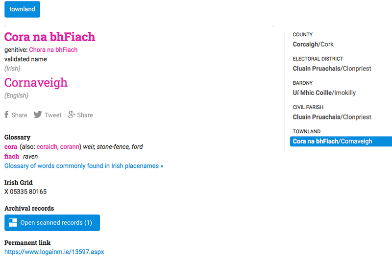
One of the key features of any map are the placenames written on it. The Placenames Database of Ireland, developed by Fiontar & Scoil na Gaeilge (DCU) and The Placenames Branch of the Department of Culture, Heritage and the Gaeltacht, is a truly marvellous website that has information on every official placename in Ireland – featuring townlands, parishes, streets, mountains, rivers and more. You can browse the website in Irish or English. This is one of those websites that we use pretty much every day.
You can search for a placename or else pan and zoom on the map and use a function to identify all placenames around a chosen point. The page for each placename gives an Irish translation and in some cases an audio file with the correct pronunciation. There are even records which show every historical reference to the placename. You can use the website’s extensive glossary to help understand the meaning of places, it really does provide a wealth of evidence to help you understand your locality.
In our case study, the Placenames Database reveals some interesting information about the townland names along the Tourig:
- Muckridge – Mucros [Wood of the Pig]
- Cornaveigh – Cora na bhFiach [Ford of the Raven]
- Meenoughter – Mín Uachtair [Upper Mountain Pasture]
- Carriganass – Carraig an Easa [Rock of the Waterfall]
You can see from these evocative placenames like these, why this can be such an interesting topic to study.
Monuments and Buildings
The most visible parts of our heritage and history are the monuments and buildings that you can find in the landscape. They provide tangible evidence of human activity and can tell us much about life in the past.
Archaeological Monuments
The National Monuments Service’s Historic Environment Viewer has details of over 130,000 archaeological monuments in Ireland, from megalithic tombs over 5,000 years old to ruined medieval churches. You can use the handy viewer to pan and zoom on the map to any part of Ireland, or search for a particular townland using the search query box on the right. Each red dot indicates an archaeological monument, while the blue dots indicate historic structures (more on that below). Click on a dot to get further information, including the monument type and a written description. The focus is on describing the physical attributes on the monument, but in many cases there is historical information and references to scholarly articles.
Historic Buildings
The National Inventory of Architectural Heritage complements the National Monuments Survey and provides information on buildings and structures dated after 1700. As with the archaeological sites, you can access information on individual sites via the online Historic Environment Viewer.
Each site is represented by a blue dot. Click on the dot to access the record for the building which includes the name, address, date and reference number. Click the ‘View Main Record’ link to get a detailed description of the site including a photo. The focus is on describing architectural features, and there are often interesting nuggets of historical information too.
Heritage Maps
Heritage Maps is another online map viewing platform and is a fantastic resource for all kinds of heritage information. It includes the details of monuments and buildings already mentioned above, but it also has information on archaeological finds, protected structures and natural heritage, amongst other things. Use the menu to the left of the map to select layers under different headings. You can find useful tools in the menu at the bottom of the screen where you can change the basemap, measure distances and areas and share maps online.
Archaeological Excavations
Archaeological excavations can give new and exciting insights into our past. You can access summaries of reports by archaeologists on Irish excavations on www.excavations.ie. Over 23,000 reports dating from after 1970 are currently available. The easiest way to access them is to use the interactive map, zoom in to the location you are interested in and click on the blue icon and then click ‘view report’ to bring up a page with a summary report.
Some of the monuments and buildings recorded along the Tourig include Kilnatoora Castle, which the National Monuments Service record tells us was besieged in 1645, and the 19th century brickworks at Muckridge, where the tall brick chimney still stands. On excavations.ie a report from 2002 has details of an archaeological dig which took place along the riverbank.


Folklore
Simply put, the National Folklore Collection of Ireland is one of the greatest treasures that the country possesses. This invaluable resource for online research is managed by the National Folklore Collection of UCD (who incidentally also have a great podcast). Their website, dúchas.ie, is a project to digitize the National Folklore Collection of Ireland.
The following resources are available on the website:
• The Schools’ Collection contains approximately 740,000 pages of folklore that was compiled by pupils from 5,000 primary schools between 1937 and 1939. This is one of the most far-sighted heritage projects ever undertaken, it has left us with such a rich resource. All volumes of the Schools’ Collection (digitized and indexed) are available on the website.
• A selection of the Photographic Collection and of the Main Manuscript Collection. The Photographic Collection contains some 80,000 photographs, the majority of which were taken between 1935 and 1970. The Main Manuscript Collection is an important record of Ireland’s oral tradition and material culture, the majority of which was collected from 1935 onwards.
• You can search by people, topics and places
• You can also get involved with the Meitheal Dúchas.ie (transcription project)
• You can also find the Irish Surname Index
All of this work is being undertaken by the Gaois research group, Fiontar & Scoil na Gaeilge, Dublin City University (DCU) in collaboration with the National Folklore Collection, University College Dublin (UCD) with funding from the Department of Culture, Heritage and the Gaeltacht (with support from the National Lottery), UCD and the Irish Folklore Foundation.
The School’s Collection is where we will focus our efforts for this online research guide. The best place to start is to click the ‘Places’ tab in the menu at the top of the homepage. This brings up a map of Ireland. You can pan and zoom to individual schools (orange markers) or places of interest (blue markers). There is a page for each school with a list of all the stories on the left hand menu and a scanned copy of the original copybook. Many stories have been transcribed by volunteers, and we strongly encourage you to get involved and help out with this wonderful resource.
This rather grim story of our area from the Schools Folklore Collection was recorded by Noel Considine of Kyle N.S.
“There are two rivers in Clasheel. One is a small stream and the other is a big river called the Tourig River. Long ago a man was found lying in the river and he was dead. When the doctors and policeman examined the body they found he was living for many days on cabbage and meal. He was called ‘the Pedelar’ and he was supposed to have money but he was a miser. His hands and feet were tied and he was strangled at Park cross”.
19th Century Historical Sources
Samuel Lewis’ Topographical Dictionary of Ireland
This was published in 1837 and is perhaps the most accessible of several 19th century printed sources. It has entries for settlements throughout Ireland right down to the smallest villages and parishes. Each entry has a description of the town/village, details of the landscape and farming, statistical data and some historical facts. You can often find nuggets of information that might not be available in other sources.
The Topographical Dictionary can be browsed online on the Library Ireland website. Simply click on a letter in the alphabetical menu to bring up an alphabetical list of towns and villages and select the town or village you want from the list.
The Tourig River is mentioned in two entries in Lewis’s Topographical Dictionary for Ardagh, Co. Cork and Templemichael, Co. Waterford. Interestingly, the river is spelled ‘Tuoro’ in one entry and ‘Turra’ in the other. There are also references to historic monuments along the river.
Griffith’s Valuation
The Griffith’s Valuation was a comprehensive survey of property ownership undertaken in the mid 19th century for taxation purposes. Nowadays it is an important resource for people tracing their ancestry. You can search the records online on the Ask About Ireland website. Searches can be done using family names, by clicking on ‘Griffith’s Names’ in the menu, and by location, by clicking on ‘Griffith’s Places’. You can get the most out of this resource if you have some idea of what you are looking for – a name or a specific place.
Individual records include the name, parish and links to the original pages and maps. You can learn about how much land a person occupied and where, who their landlord was and what the value of their property was. Ask About Ireland, a collaboration between Ireland’s public libraries, also has a wide selection of e-books in their online reading room. You can browse the e-books by subject or by county. The reading room contains rare and out of print books, many from the 19th and early 20th centuries. Of particular interest are the volumes of the Civil Survey, a detailed survey of land ownership in the mid 1600s.
Other Sources for your Online Research Guide
The Lawrence Photographic Collection, National Library of Ireland
The National Library of Ireland holds a vast array of material of Irish interest. The Lawrence Photographic Collection is undoubtedly one of their most absorbing collections. It contains over 36,000 photographs taken between 1860 and 1920 across Ireland. You can find photographs of public buildings, antiquities, streetscapes and much more. Many of the photographs have been digitised and can be viewed online. To access the collection, go to catalogue.nli.ie and search for ‘Lawrence Photograph Collection’. When you click into the collection, you can filter the photographs by location, subject and date. You can also click on a thumbnail image to view it in larger size.
A photograph of Youghal Bridge and Harbour in the Lawrence Collection shows the point close to where the Tourig River enters the harbour.
Irish Genealogy
With the growing interest in tracing family history, Irish Genealogy provides access to a vast amount of records of births, marriages and deaths. Both church and civil records can be searched. Like Griffith’s Valuation, you can get the most out of this website if you are searching for a particular individual. You can also find an online research guide with useful information and tips on how to research your family history. A related resource is 2016 Family History. Created by the National Archives it provides an online course in how to get started researching your family history.
1641 Depositions
Ireland was convulsed by rebellion in 1641 when the native Irish rose up against English settlers. In the aftermath, a commission was set up which took over 8,000 witness statements, mainly from Protestants caught up in the conflict. Following a project involving Trinity College Dublin, these first-hand accounts can be read online and are an exceptional historical resource.
You must register an account on the website to access the depositions. You can browse the depositions by county using the map on the homepage or search by name. The depositions have been transcribed in the 17th century English in which they were originally written.
This is just a short selection of some essential tools for your online research guide. Do you have any particular sources that you like to use? Please leave a comment below and let us know!
Leave A Comment